Character and identity
Spandau is the namesake district of the borough of the same name in the far northwest of Berlin, where the Spree flows into the Havel. Across roughly 8.03 square kilometres, 42,775 people live (source: Amt für Statistik Berlin-Brandenburg). They are spread across 21,060 households and 21,821 apartments.
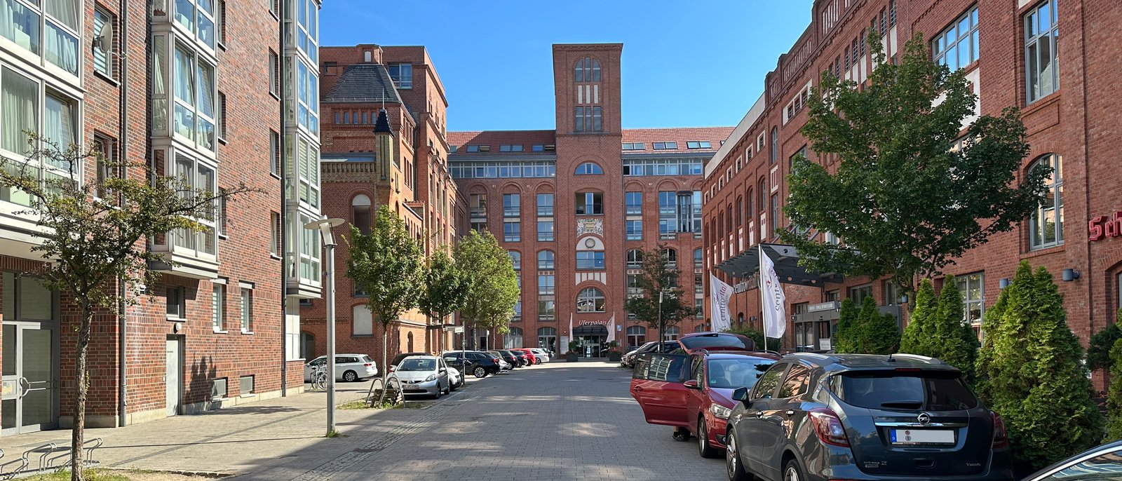
Those who speak of Spandau often mean two things. On the one hand the large borough with its nine districts, on the other this historic core: the old town with its pedestrian zone, the Neustadt, the Stresow quarter around the long-distance station. It is precisely this core that carries the long independence that shapes Spandau to this day. Spandau probably received its town charter in 1232 and remained a town in its own right at the gates of Berlin for centuries. Only in 1920 was it incorporated as part of the Greater Berlin Act. This late affiliation has left behind a self-image that many residents maintain to this day: you live in Spandau, and only then in Berlin.
The sense of life in the district moves between small town and city edge. In the old town, shops, cafes, and restaurants line one of the largest contiguous pedestrian zones in Berlin, against the backdrop of preserved and reconstructed buildings. A few steps further runs the Lindenufer, a promenade right on the Havel. This proximity to the water is a recurring motif: the Havel and Spree frame the district and give it access to the waterfront in several places, something that has become rare in the denser inner-city boroughs.
At the same time, Spandau is a place of contrasts. The medieval street network of the old town and the Kolk stands opposite the residential rows of the post-war period and the transport structures of the 1960s and 1970s. The Berlin-Spandau station and the adjacent shopping centre form a modern gateway, while the Reformationsplatz quarter marks the historic centre. Spandau therefore works less as a single quarter than as a juxtaposition of layers that touch in close quarters.
History and change
The history of Spandau begins long before Berlin. As early as the 7th century, Slavic tribes settled in the Havelland, and by the end of the 10th century a fortified castle complex had emerged at the confluence of the Spree and Havel. Burg Spandau was first mentioned in records in 1197, and the town itself is documented from 1232. This makes Spandau one of the oldest settlement cores in the region and older than the first secure mention of Berlin as the twin town of Berlin-Cölln.
Its military function became formative. Around 1560 Elector Joachim II had the old castle expanded into a state fortress, from which the Zitadelle emerged. For centuries Spandau remained a fortress and garrison town. This had concrete consequences for urban development: in the so-called fortress rayon around the complex, building was long permitted only to a limited extent, which slowed the town's expansion and keeps the compact old town recognisable to this day.
With industrialisation in the 19th century, the place changed. Armament plants and gun factories settled there, the population grew, and Spandau became an industrial location with its own economic strength. The Second World War brought this development to an end. Because of the weapons production, Spandau was the target of heavy air raids in late autumn 1944 and early 1945, which destroyed much of the old town. A large part of the surviving building fabric was lost in the post-war period, through the radical redevelopment of the 1950s and the later underground construction.
The more recent history of the district is one of reconstruction. Between 1978 and 1989 the old town was redesigned as a pedestrian zone. With the opening of the Spandau Arcaden at the station in 2001, the traditional retail of the old town faced large-scale competition close by for the first time. Since 2020 the Spandauer Neustadt has been under milieu protection as a preservation area, an instrument with which the borough aims to keep the composition of the resident population stable in the densely built quarter.
Sights
The best-known structure stands at the northern edge of the district, on a Havel island at the border with neighbouring Haselhorst: the Zitadelle Spandau with the Juliusturm. The square 16th-century fortress is surrounded by water and is among the best-preserved Renaissance fortresses in Europe. The Juliusturm is considered the oldest surviving building in Berlin. Today the Zitadelle houses a museum and is the scene of open-air concerts in summer.
At the centre of the old town lies the Reformationsplatz with the St.-Nikolai-Kirche. The late-Gothic hall church is considered the starting point of the Reformation in Brandenburg; here in 1539 the sovereign's conversion to the Protestant faith took place. Just a few streets away stands the Gotisches Haus on Breite Straße, a late-medieval town house from the 15th century that is considered the oldest surviving residential building in Berlin and today houses the tourist information office as well as an exhibition on the town's history.
A chapter of its own is the Kolk, the oldest settlement area within the old town. In its narrow lanes, remains of the old town wall and a few half-timbered houses have survived, giving an impression of pre-industrial Spandau. By the water, the Lindenufer adjoins, whose newly designed Stabholzgarten behind the town hall complements the Havel promenade. The Rathaus Spandau itself, a massive building at the transition between the old town and Stresow, marks a widely visible orientation point with its tower.
Popular Kieze in Spandau
- Altstadt: The historic core with pedestrian zone, Reformationsplatz, and St.-Nikolai-Kirche. Here retail, restaurants, and the weekly market concentrate, embedded in the medieval street network.
- Spandauer Neustadt: Densely built residential quarter north of the old town, shaped by 19th-century and post-war buildings. A preservation area under milieu protection law since 2020.
- Kolk and Behnitz: Spandau's oldest residential area with town-wall remains and half-timbering, quietly located between the old town and the Havel.
- Stresow: Quarter around the Berlin-Spandau station and the Spandau Arcaden, with good connections and a mix of residential and commercial use.
Scene and everyday life
Everyday life in the district plays out largely in and around the old town. At the market on Reformationsplatz and along the pedestrian zone, daily shopping takes place, complemented by the roughly hundred shops of the Spandau Arcaden at the station. This dual structure of historic street retail and covered shopping centre determines the district's supply offering.
In the events calendar, Spandau has several fixtures. The Spandau Christmas market in the old town is one of the largest in Berlin and draws visitors from across the city every year. In summer, public life shifts to the Lindenufer and into the Zitadelle, whose concert series brings national and international artists into the fortress walls. Added to this are town festivals and markets that animate the old town and the waterfront zones.
Culturally, it is above all the combination of history and water that shapes the character. The museums in the Zitadelle and the Gotisches Haus, the churches of the old town, and the promenades on the Havel and Spree form an offering that relates more to the place and its past than to the clubs and galleries of the inner boroughs. In everyday life Spandau works as a manageable unit with short distances, in which shopping, restaurants, and local recreation combine in close quarters.
Who lives in Spandau
The district's population, at 42,775 people, is medium-sized compared with Berlin as a whole. The following breakdown shows how the households are distributed across single, couple, and family households.
| Household size | Count | Share |
|---|---|---|
| 1 person | 12,645 | 60 % |
| 2 people | 4,534 | 22 % |
| 3 people | 1,934 | 9 % |
| 4 people | 1,170 | 6 % |
| 5 people | 434 | 2 % |
| 6+ people | 343 | 2 % |
The distribution of household sizes places Spandau within the Berlin pattern, in which small households dominate, but at the same time reveals how strongly families are represented in the district. Reading this together with the age structure gives a more precise picture of which generations live here.
| Age group | Count | Share |
|---|---|---|
| under 6 | 2,570 | 6 % |
| 6–15 | 3,840 | 9 % |
| 15–18 | 1,169 | 3 % |
| 18–27 | 5,173 | 12 % |
| 27–45 | 12,862 | 30 % |
| 45–55 | 4,867 | 11 % |
| 55–65 | 5,289 | 12 % |
| 65+ | 7,005 | 16 % |
The district's international character is also telling. Over the years Spandau has taken in people from very different regions of origin, which is reflected in the composition of the resident population.
| Region of origin | Count | Share |
|---|---|---|
| EU | 5,573 | 32 % |
| Turkey | 2,820 | 16 % |
| Ukraine | 2,401 | 14 % |
| Syria | 1,479 | 8 % |
| unassigned | 1,011 | 6 % |
| India | 870 | 5 % |
| Russia | 821 | 5 % |
| Afghanistan | 626 | 4 % |
| Iran | 392 | 2 % |
| Vietnam | 381 | 2 % |
| Lebanon | 341 | 2 % |
| Iraq | 311 | 2 % |
| Kazakhstan | 218 | 1 % |
| China | 151 | <1 % |
| USA | 148 | <1 % |
| United Kingdom | 148 | <1 % |
These three perspectives, household size, age, and origin, describe a district that cannot be classified purely as a family quarter or as a single-person location. The mix is more the hallmark: a juxtaposition of long-established households, young newcomers, and families that is distributed differently across the various neighbourhoods.
Who is drawn to Spandau
The migration data show how the population renews itself. The district's growth is carried by international inflow, while in the exchange with the surrounding area and the rest of Germany people move away on balance, above all German nationals.
| # | Country | Inflow | Outflow | Net |
|---|---|---|---|---|
| 1 | Ukraine | 320 | 164 | 156 |
| 2 | Indien | 224 | 102 | 122 |
| 3 | Rumänien | 93 | 114 | -21 |
| 4 | Türkei | 92 | 61 | 31 |
| 5 | Arabische Republik Syrien | 86 | 74 | 12 |
| 6 | Afghanistan | 74 | 100 | -26 |
| 7 | Bulgarien | 67 | 170 | -103 |
| – | Deutschland | 594 | 959 | -365 |
Within Berlin, the interconnection is small-scale. Most new residents come from neighbouring Tegel and the surrounding Spandau districts.
| # | District | People |
|---|---|---|
| 1 | Tegel | 512 |
| 2 | Hakenfelde | 198 |
| 3 | Falkenhagener Feld | 196 |
| 4 | Wilhelmstadt | 180 |
| 5 | Charlottenburg | 164 |
In the opposite direction the movement remains similarly close: most of those moving away stay within the borough.
| # | District | People |
|---|---|---|
| 1 | Hakenfelde | 331 |
| 2 | Falkenhagener Feld | 241 |
| 3 | Staaken | 240 |
| 4 | Wilhelmstadt | 217 |
| 5 | Charlottenburg | 131 |
Buildings and apartments
The district's building stock comprises 2,335 buildings. The range extends from the narrow plots of the old town through the 19th-century blocks of the Neustadt to the residential rows of post-war modernism. The distribution of living areas shows how large the apartments in the district turn out to be.
| Size class | Count | Share |
|---|---|---|
| Unter 40 m² | 2,294 | 11 % |
| 40-59 m² | 7,844 | 36 % |
| 60-79 m² | 7,181 | 33 % |
| 80-99 m² | 2,923 | 13 % |
| 100-119 m² | 959 | 4 % |
| 120-139 m² | 382 | 2 % |
| 140-159 m² | 113 | <1 % |
| 160-179 m² | 64 | <1 % |
| 180-199 m² | 15 | <1 % |
| 200+ m² | 41 | <1 % |
The apartment sizes give an indication of which households the stock is suited to, from compact units in the Neustadt to larger apartments in the quieter locations. Closely connected to this is the question of how many apartments are owner-occupied and how many are rented.
| Type of use | Count | Share |
|---|---|---|
| Rented | 19,573 | 88 % |
| Owner-occupied | 1,761 | 8 % |
| Vacant | 476 | 2 % |
| Commercial | 341 | 2 % |
For new development, the borough has for years relied on activating former industrial and brownfield sites. Within the district and on its edges, new apartments arise above all where formerly commercially used areas on the water are rezoned. The following display makes visible how building activity has developed over time.
| Period | Apartment balance |
|---|---|
| 2021 | 33 apartments |
| 2022 | 11 apartments |
| 2023 | 121 apartments |
| 2024 | 27 apartments |
Transport and infrastructure
Despite its peripheral location, Spandau is well connected to the Berlin and supraregional network. The Berlin-Spandau station is a long-distance stop: from here ICE and IC trains run towards Hamburg, Hanover, and the western part of Germany. Regional express lines such as the RE4 and the RE6 (Prignitz-Express) connect the district with the Berlin centre and the surrounding Brandenburg area. Via the S3 suburban line, you can reach the city centre, the main station, and the east of the city from Spandau without changing.
In the underground network, the Rathaus Spandau station forms the western terminus of the U7 line, the longest underground line in Berlin. On its way through the district it also stops at the Altstadt Spandau and Zitadelle stations before continuing south via Haselhorst. Around Rathaus Spandau and the long-distance station, numerous bus lines converge, opening up the surrounding districts and nearby Brandenburg.
For car traffic, Spandau is connected via the Heerstraße (B5) and the Falkenseer Damm, which link the centre with the western surrounding area. Within the district, the old town as a pedestrian zone is largely car-free. The location on the Havel and Spree also makes the paths along the water attractive for cyclists and pedestrians, for instance along the Lindenufer and the adjoining waterfront paths.
The district's basic provision is well covered by the old town and the Spandau Arcaden, which together bundle a broad retail offering. Schools, day-care centres, and medical practices are distributed across the old town, Neustadt, and Stresow. With the Rathaus Spandau, the administrative centre of the entire borough is also located in the district, which keeps trips to public offices short.
With green spaces, Spandau benefits from its location on the water. The Lindenufer and the Stabholzgarten, together with the waterfront paths on the Havel and Spree, form local recreation close to homes. Combined with the larger green and forest areas of the neighbouring districts, this creates an environment that offers plenty of open space despite its proximity to the city centre. This mix of historic core, short distances, and waterfront location is what characterises the Spandau district compared with Berlin as a whole.
Who Spandau suits
- Commuters with a western connection: The Berlin-Spandau station (ICE, regional services, S3) and the U7 bring the city centre reliably within reach; the peripheral location, however, means longer trips to nightlife and the cultural scene.
- Families needing space and water: Waterfront location, riverside promenades, and lower density outside the old town, plus a high share of larger households; quiet residential locations are more on the edges.
- Resale investors eyeing conversion sites: Milieu protection in the Neustadt since 2020 regulates conversions, while at the same time the redevelopment of former industrial sites expands the stock; the energy profile is relevant to the renovation need.